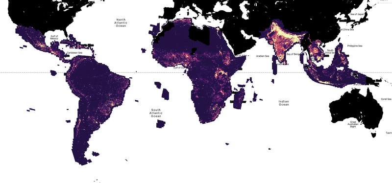
Google Research has released the Open Buildings 2.5D Temporal Dataset, a project that tracks building changes across the Global South from 2016 to 2023.
This exceptionally detailed dataset offers a dynamic, year-by-year view of urbanization. It captures building construction, growth, and transformation across regions where such data has long been scarce or nonexistent.
John Quinn, a software engineer at Google Research, explained why the project is important: “Not knowing where buildings are is a big problem for lots of practical reasons. If you’re creating services or vaccination campaigns or rescuing people after an emergency, this is an issue.”
The tool’s primary breakthrough is its ability to extract high-resolution insights from low-resolution Sentinel-2 satellite imagery.
By analyzing up to 32 time-shifted images of the same location, the AI can detect structures far smaller than a single pixel.

Beyond detection, the system estimates building heights with remarkable precision – within 1.5 meters on average.
This transforms flat satellite images into rich, multi-layered data, providing urban planners and humanitarian organizations with a powerful instrument for understanding population density and resource needs.
Mapping the Global South
The term “Global South” typically refers to developing nations in Africa, Asia, Latin America, and the Caribbean.
These regions, home to the majority of the world’s population, often face challenges in delivering high-quality healthcare, urban development, environmental conservation, and resource management.
Abdoulaye Diack, a program manager on the project, stated, “We want people in the global South making policy decisions to have the same tools available as the global North.”
The dataset is already finding practical applications. In Uganda, the nonprofit Sunbird AI is leveraging this data for rural electrification projects.
WorldPop, based at the University of Southampton, is using it to refine global population estimates – critical information for planning everything from vaccination campaigns to disaster response.
WorldPop’s director, Professor Andrew Tatem, explained why this data is important: “Understanding where people live is vital for making sure that resources are distributed fairly and that no one is left behind in delivering services like healthcare.”
AI is enhancing satellite and 3D mapping, providing more accurate and timely insights into urban growth and environmental shifts.
For example, a recent project by Aya Data in Ghana employed AI to analyze thousands of satellite images of South America, tracking changes in forests, urban areas, and agricultural land over several years.
The AI’s skill in detecting subtle changes, such as early signs of deforestation or new developments, informs real-world agriculture and conservation policies.
Beyond observing long-term shifts in the environment, AI enables researchers to detect and respond to threats like illegal logging, wildlife poaching, and unauthorized changes in land use visible from satellite imagery.
Google admits that its dataset has limitations. Persistent cloud cover can impede data collection in some of the world’s most humid regions, and very small structures may also elude detection.
Nevertheless, the Open Buildings 2.5D Temporal Dataset is an excellent example of the powerful synergy between data democratization and AI.
By democratizing access to complex geospatial information, it paves the way for more equitable urban planning, disaster preparedness, and sustainable development on a global scale.


