
Researchers have uncovered insights into global maritime activities using neural networks to analyze satellite and radar images.
This study, published in Nature and led by Fernando Paolo of Global Fishing Watch, a Washington DC-based non-profit, reveals that three-quarters of the world’s large fishing vessels and a quarter of transport and energy ships operate as “dark vessels,” not sharing their locations publicly.
Fernando Paolo explained, “Historically, vessel activity has been poorly documented, limiting our understanding of how the world’s largest public resource—the ocean—is being used.”
“We had an idea that we were missing a big chunk of the activity happening in the ocean, but we didn’t know how much. And we found that it’s a lot more than we imagined.”
Using data spanning 2017 to 2021, the team analyzed GPS, satellite, and radar images from coastal areas where major fishing and industrial operations tend to be concentrated. They trained multiple neural networks to spot and classify boats and offshore structures within these images.
The resulting analysis showed that most of the approximately 63,000 vessels tracked didn’t consistently use automated identification systems, raising concerns about illegal activities like unregulated fishing.
One AI was specifically trained to distinguish fishing vessels based on their travel patterns and locations, finding that 42 to 49% of the vessels were classified as fishing boats.
Study co-author Jennifer Raynor, assistant professor of natural resource economics at the University of Wisconsin-Madison, stated, “By revealing dark vessels, we have created the most comprehensive public picture of global industrial fishing available.”
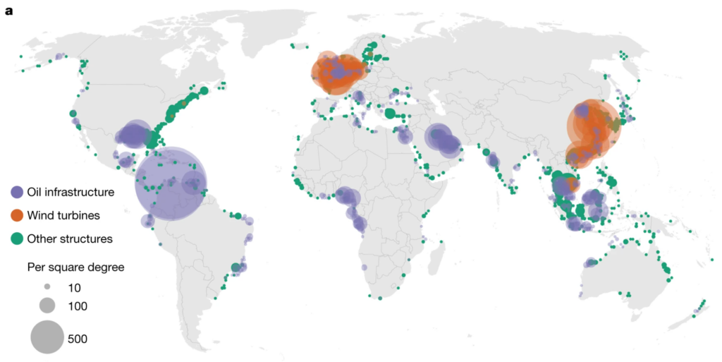
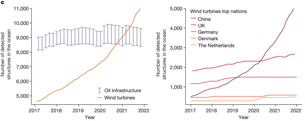
Furthermore, the study identified 28,000 offshore structures, including those involved in wind power and oil production, with a notable rise in offshore wind turbines.
The number of oil structures saw a 16% rise during the study period, but even more notably, the count of wind turbines more than doubled, surpassing oil platforms by 2021.
The growth in offshore wind energy was particularly pronounced in China, which experienced a ninefold increase from 2017 to 2021.
More about the study
The study conducted by Global Fishing Watch mapped industrial activities at sea with the assistance of neural networks.
Here’s more information about how it worked:
- Data collection and integration: Between 2017 and 2021, the team gathered a vast amount of data, including 2 petabytes of satellite imagery, vessel GPS data, and deep-learning models. This data covered the world’s coastal waters, where over 75% of industrial activity is concentrated.
- Deep learning model development: They developed three deep convolutional neural networks. These networks were designed for specific tasks: identifying objects and estimating their lengths with high accuracy, classifying offshore infrastructure into categories like oil, wind, and other structures, and distinguishing between fishing and non-fishing vessels.
- Analysis of satellite imagery and vessel GPS data: The researchers analyzed satellite imagery to detect vessels and offshore structures and then matched these findings with GPS data from vessels publicly broadcasting their location. This revealed that a significant portion of industrial fishing vessels (72 to 76%) and other vessels (21 to 30%) were not publicly tracked.
- Mapping and of activities: The team mapped vessel activities and offshore energy infrastructure, highlighting the distribution and concentration of these activities in coastal waters. They discovered that fishing activity decreased significantly during the COVID-19 pandemic, while transport and energy vessel activities remained relatively stable.
- Evaluation of environmental impact: Finally, the researchers identified potential hotspots for illegal fishing and quantified the scale of vessel activities, including the rapid growth of offshore wind infrastructure, which surpassed the number of oil structures by 2021.
The researchers hope this map can now assist in managing and understanding future human activities in the ocean.
As co-author Patrick Halpin, professor of marine geospatial ecology at Duke University, states, “The footprint of the Anthropocene is no longer limited to terra firma,” meaning human activity in this current epoch has penetrated every corner of the planet.


